- Earthquake -
Photo id: 254982 - Loma Prieta, California, Earthquake October 17, 1989. Watsonv...Loma Prieta, California, Earthquake October 17, 1989. Watsonville area. Collapsed bridge section on Highway 1 at Struve Slough. Slide XIV-12, U.S. Geological Survey Open-File Report 90-547. - ID. Nakata, J.K. 37ct - njk00037 - U.S. Geological Survey - Public domain imageDimensioni del file: 65153 bytes Foto visualizzata 1003 volte
|
Photo id: 259099 - Loma Prieta, California, Earthquake October 17, 1989. Watsonv...Loma Prieta, California, Earthquake October 17, 1989. Watsonville area. Broken utility lines in a house that shifted off its foundation in downtown Watsonville. 1989. Slide XIV-8, U.S. Geological Survey Open-File Report 90-547. - ID. Wilshire, H.G. 17ct. - whg00017 - U.S. Geological Survey - Public domain imageDimensioni del file: 63511 bytes Foto visualizzata 990 volte
|
Photo id: 252284 - Yellowstone National Park, Wyoming. Earthquake camp, near Ste...Yellowstone National Park, Wyoming. Earthquake camp, near Steamboat Point, on the east side of Yellowstone Lake, so named from several slight shocks of earthquake which were experienced at this place on the night of August 19, 1871. 1871.U.S. Geological and Geographical Survey of the Territories (Hayden Survey). - ID. Jackson, W.H. 106 - jwh00106 - U.S. Geological Survey - Public domain imageDimensioni del file: 38300 bytes Foto visualizzata 144 volte
|
Photo id: 255030 - Hebgen Lake, Montana, Earthquake August 1959. Gap formed alon...Hebgen Lake, Montana, Earthquake August 1959. Gap formed along the Hebgen fault scarp. In most places the debris that was cut and offset by the fault collapsed and closed this cap; but loca11y, as shown here, the gap remained open wide enough to accommodate a man. August 1959. - ID. Stacy, J.R. 3ct - sjr00003 - U.S. Geological Survey - Public domain imageDimensioni del file: 71431 bytes Foto visualizzata 361 volte
|
Photo id: 252348 - Imperial Valley, California, Earthquake October 15, 1979. Imp...Imperial Valley, California, Earthquake October 15, 1979. Imperial Fault trace west of Anderholt Road in alfalfa fields as it appeared shortly after the earthquake of May 18, 1940. Unpaved Anderholt Road cuts diagonally across the upper right. The dark band west of and parallel to the road is Ash Lateral 15 canal. Photo by R.V. Sharp, 1940. Figure 154-A, U.S. Geological Survey Professional paper 1254. See also photo jce00024. - ID. Johnson, C.E. 23 - jce00023 - U.S. Geological Survey - Public domain imageDimensioni del file: 30157 bytes Foto visualizzata 601 volte
|
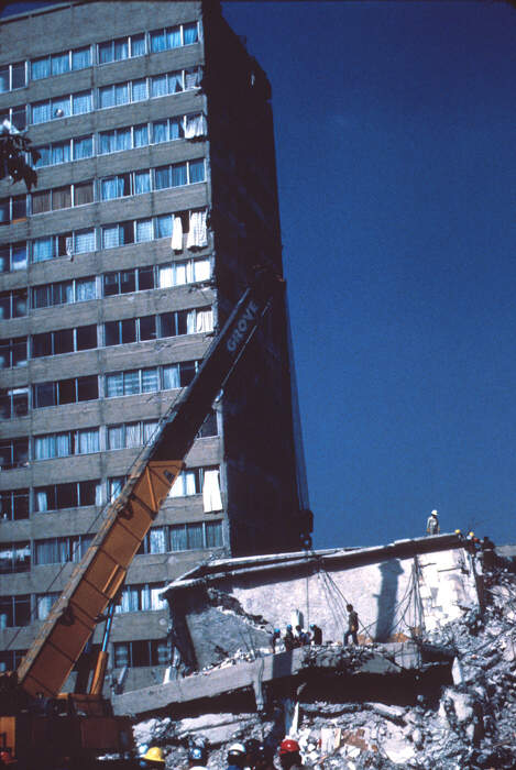
Photo id: 259211 - Mexico City Earthquake, September 19, 1985. Nuevo Leon fiftee...Mexico City Earthquake, September 19, 1985. Nuevo Leon fifteen-story reinforced concrete structure. Part of the building was only slightly damaged, while another part of it collapsed. 1985. Photos cel00032 through cel00034 provide a sequence of views. - ID. Celebi, M. 33 - cel00033 - U.S. Geological Survey - Public domain imageDimensioni del file: 67917 bytes Foto visualizzata 1039 volte
|
14 15 16 17 18 19 20 21 22 23 24 25 26 27 28
Immagini trovate: 693
AVG: 331.457 (1039)


